Más Información

Una carta, una pausa, y el rechazo a peticiones; los jaloneos entre México y España por las disculpas de la Conquista

Harfuch se reúne en Washington D.C. con director de la DEA; hablan sobre combate al narco y al tráfico de armas

Nodal narra el miedo que experimentó durante el fuego cruzado que presenció en Zacatecas: "me tocó tirarme al piso"

Así pagaba “El Mencho” su base social; 8 mil para diálisis, 230 mil para posadas, un millón para niños en Navidad

Cuba abre la puerta a inversiones de su diáspora; podrán asociarse con una entidad pública o privada
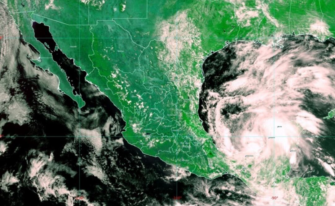
A tropical depression that formed Monday in the Gulf of Mexico is forecast to become a tropical storm in the coming hours that could bring heavy rains and flash flooding to parts of southern Mexico and Central America.
The U.S. National Hurricane Center said the depression was centered late Monday about 150 kilometers west-southwest of Campeche , Mexico. At 11 p.m. EDT, the storm had maximum sustained winds of 45 kph and was crawling westward near 11 kph.
Forecasters said it could reach tropical storm status during the night or sometime Tuesday .
The government of Mexico has a tropical storm warning in effect from Campeche to the port of Veracruz on that country’s Gulf coast. The warning means tropical storm conditions are expected somewhere in that warning area within 36 hours.
The Miami-based hurricane center said the storm is expected to unleash heavy rains with potential accumulations of 25-40 centimeters over parts of the Mexican states of Tabasco and Veracruz and adjacent portions of Guatemala .
Recommended: What to do in case of a hurricane?
Forecasters added that 12-25 centimeters of rain could fall on parts of El Salvador and Honduras with possibly higher amounts in isolated areas.
Tropical Storm Cristobal
formed in the southern Gulf of Mexico on Tuesday , threatening to bring deadly flooding in parts of southern Mexico and Central America.
Cristobal was the earliest third named storm of an Atlantic hurricane season on record; in 2016, Tropical Storm Colin formed in the Gulf on June 5.
The U.S. National Hurricane Center said Cristobal was centered about 200 kilometers east-northeast of the oil city of Coatzacoalcos and was heading to the southwest at 6 kph. It had maximum sustained winds of 65 kph.
Forecasters said it is likely to wander just off Mexico’s Gulf coast during the week before veering northward across the Gulf as a strong tropical storm with winds of as much as 105 kph. It is too early to say when and where it might strike the United States , but the projected path would send it toward the U.S. Gulf Coast over the weekend.
Recommended: Hurakán, the Mayan god of storms
Dennis
Feltgen
, a spokesman for the National Hurricane Center, urged Gulf Coast residents to keep an eye on Cristobal , noting “there is no such thing as ‘just a tropical storm’.”
A tropical storm warning was in effect across the southern arc of the Gulf from Campeche to the port of Veracruz, though the biggest effect was likely to be rainfall accumulations of 25 to 50 centimeters and even more in isolated areas.
That poses a special risk to the Pacific coastal areas of southern Mexico , Guatemala , and El Salvador, which were already drenched.
Cristobal formed from the remnants of the Eastern Pacific’s Tropical Storm Amanda , which killed at least 17 people as it moved across El Salvador and Guatemala over the weekend.
Because Amanda broke up after crossing over Guatemala and El Salvador into the Gulf, where Cristobal formed, it is not technically a “cross-over” storm that moved from the Pacific to the Atlantic, though that has occurred in the past.
But Amanda and Cristobal will soak some of the same areas , Feltgen noted.
“Unfortunately, the rain is falling in the same general area,” said Feltgen. “There are areas that will probably be measuring the rain in feet, not inches. ... That is catastrophic .”
Recommended: Natural disasters: The high cost of climate change
mp
Noticias según tus intereses
[Publicidad]
[Publicidad]


