
Más Información
/cloudfront-us-east-1.images.arcpublishing.com/eluniversal/2P5JQX5DDND67FT5LO3FJYT2MM.jpg)

/cloudfront-us-east-1.images.arcpublishing.com/eluniversal/ZUMCQ57CWVA4XAG2EMU3TVPYJA.jpg)
/cloudfront-us-east-1.images.arcpublishing.com/eluniversal/XPWJ6QLN2RCMHITXZYLUBV6QAQ.jpg)

In 2012, U.S archaeologist Christopher Fisher and his team – comprised of archeologists from Mexico, the United States, Canada, and Europe – performed a scanning of the archaeological site known as Angamuco, in Michoacán, using LIDAR technology , which allowed them to detect several structures hidden by the dense vegetation.
While Fisher and his team first discovered the city in 2007, the archaeologist explains that the site exploration has just begun, reason why there isn't a lot of information available.
Thanks to the mapping, they now have an idea of the dimensions of this urban settlement reaching across 26 square kilometers. According to the archaeologists, they estimate there are around 39,000 structures , the same amount of buildings in Manhattan, yet unlike the famous New York City, in Angamuco most of the structures belong to small houses, retention walls, farming terraces, roads, and two pyramid bases. Moreover, they theorize not all the structures were built and occupied at the same time.

(Image of the LIDAR scanning, showing structures hidden in the vegetation – Image: Courtesy of CHRISTOPHER FISHER)
According to the archaeologist, Angamuco was first built around the 900 B.C. and may have been inhabited until 1350 A.D. Yet the history behinds its growth, development, and the people who lived there is still an unsolved puzzle.
“We named it 'Angamuco' because when we first began to document it we had no idea of what site this was, how it was called, or how did the people who lived there called it,” explained the Mexican archaeologist Rodrigo Solinis-Casparius , who is working on the project.
He further detailed the site was found while they were performing another project, which included understanding the development of the Pátzcuaro lake basin during the Pre-Hispanic era.
The team looked for the city in ancient maps and in ethnohistoric sources but there was no record of the city. Finally, upon registering the project before the Archaeology Board of the INAH, they named the city 'Angamuco,' a name taken from a map left by friar Pablo Beaumont on Purépecha territories.
“This map shows some settlements, and there is one which names this place Angamuco, so we took the name from there.”
Solinis-Casparius adds that the lack of information is probably a sign that the city had already been abandoned prior to the arrival of the Spanish conquistadors, yet this, among other questions, remain a mystery.
“We're still working to find out what happened in the city, to know who lived there, how many, how did they live...it's still a puzzle,” said Solinis-Casparius.

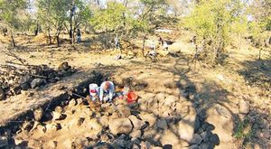
(View of the area – Photo: Rodolfo Ayala/EL UNIVERSAL)
Christopher Fisher agrees that an answer to these questions will only be possible through further exploration of the site – a work that they are only able to perform two months each year.
“Archaeology takes a long time. This is why the LIDAR technology is so fascinating because in 45 minutes you can obtain data that could take 10 or 15 years to get if you were to do it the traditional way,” says Fisher, who says they will still need to do some traditional digging.
The U.S. archeologist did clarify that the comparison he made of the city with Manhattan was “to give an idea” to people in the U.S. about the extension of Angamuco and not on terms of population density, as the news – which went viral – seemed to imply.
am